👋 About Me
I am a Ph.D. student in the Department of Geography at the University of Wisconsin–Madison, affiliated with the
Spatial Computing and Data Mining Lab.
My research focuses on remote sensing and GeoAI, with particular interests in:
- Hyperspectral and multispectral image modeling
- Natural hazards (e.g., wildfire monitoring and damage assessment)
- Precision agriculture and environmental sensing
- Deep learning and representation learning for geospatial data
I am especially interested in learning physically meaningful and efficient representations for high-dimensional Earth observation data, bridging modern deep learning with remote sensing theory.
🔬 Current Research Topics
- Hyperspectral image generation from extremely sparse multispectral observations
- Transformer-based spectral–spatial modeling for remote sensing imagery
- Wildfire burnt area and burn severity mapping using bi-temporal Sentinel-2 data
- Hydrological streamflow prediction with graph neural networks
In the long term, I aim to develop generalizable, interpretable, and efficient spatiotemporal learning frameworks for disaster monitoring and environmental applications.
📫 Contact
Email: tsui5@wisc.edu
📚 Google Scholar ·
ResearchGate
🔥 News
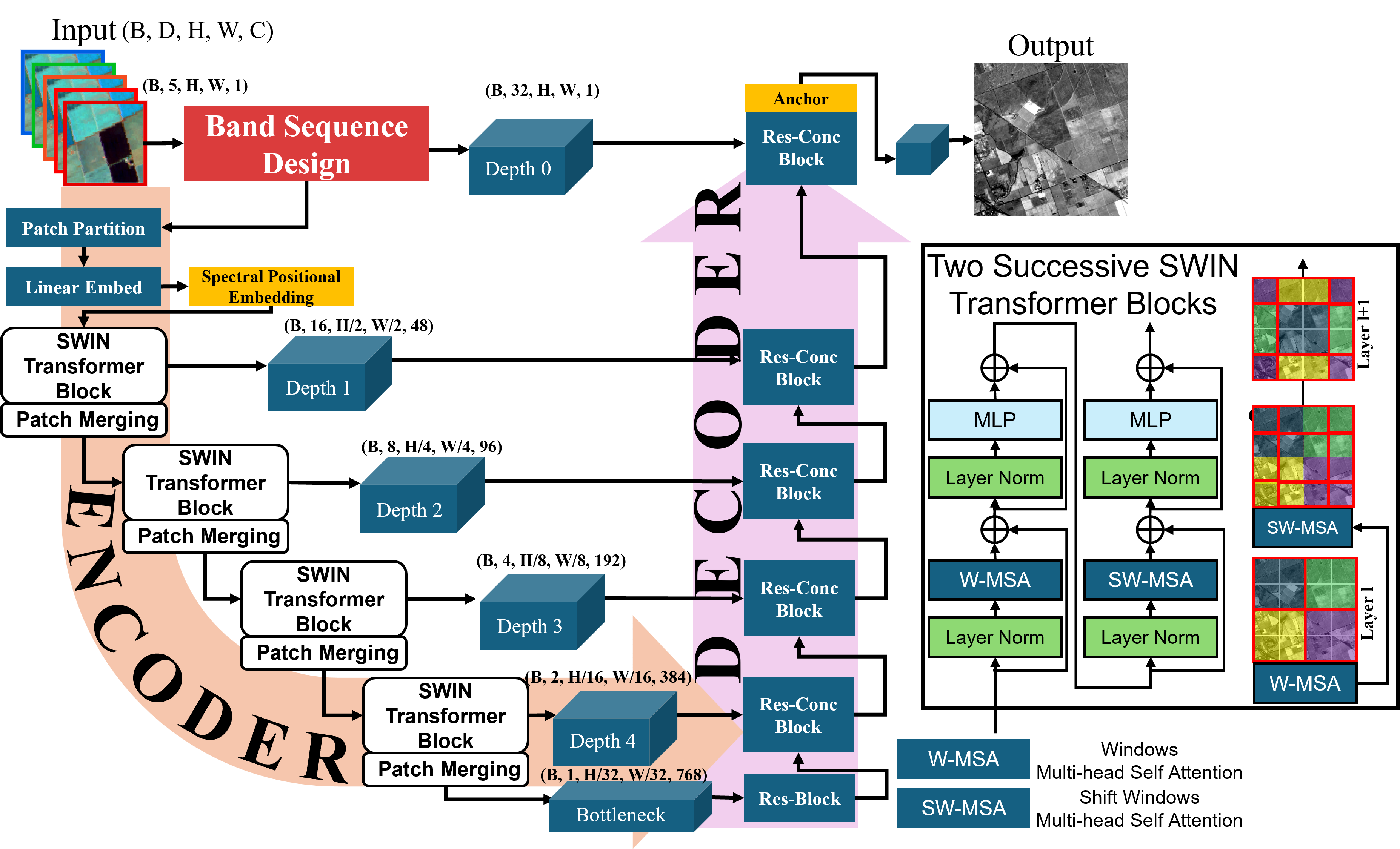
- 2026.02 🎉 SpecSwin3D published in IEEE Transactions on Geoscience and Remote Sensing (TGRS)
- 2025.09 🎉 Our paper SpecSwin accepted at the GeoSIM Workshop @ ACM SIGSPATIAL 2025
- 2025.07 🏆 Fourth Place, Remote Sensing Competition, AAG Annual Meeting 2025
- 2024.08 🎓 Started Ph.D. program at UW–Madison
- 2024.06 📝 Wildfire burnt area mapping paper accepted in IJAEOG
📝 Selected Publications
📌 Journal Articles
SpecSwin3D: Generating Hyperspectral Imagery from Multispectral Data via Transformer Networks and Curriculum-Based Cascade Training
Tang Sui, Songxi Yang, Qunying Huang
IEEE Transactions on Geoscience and Remote Sensing (TGRS), 2025
Paper ID: TGRS-2025-07524
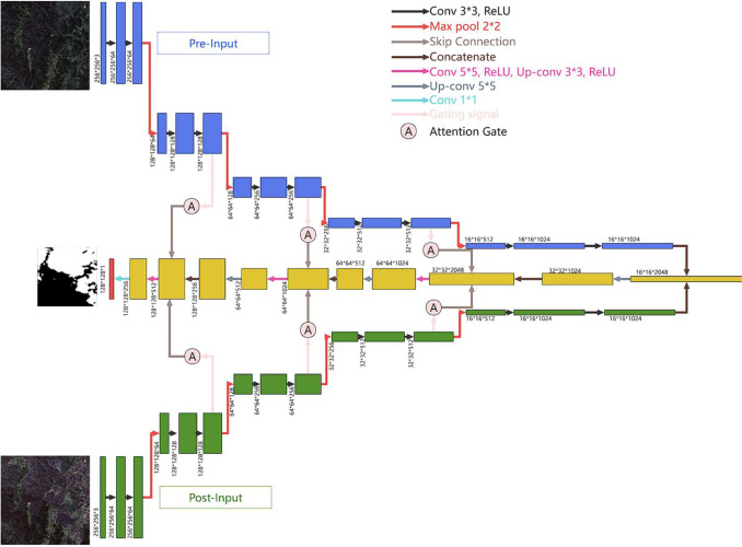
BiAU-Net: Wildfire Burnt Area Mapping Using Bi-Temporal Sentinel-2 Imagery and U-Net with Attention Mechanism
Tang Sui, Mingda Wu, Meiliu Wu, Zhou Zhang, Qunying Huang
International Journal of Applied Earth Observation and Geoinformation, 2024
A Remote Sensing Spectral Index Guided Bitemporal Residual Attention Network for Wildfire Burn Severity Mapping
Mingda Wu, Tang Sui, Bo Peng, Manzhu Yu, Qunying Huang
IEEE Journal of Selected Topics in Applied Earth Observations and Remote Sensing (JSTARS), 2024
Self-supervised Pretraining with Edge Guidance for Building Damage Assessment
Songxi Yang, Bo Peng, Tang Sui, Qunying Huang
7th ACM SIGSPATIAL AI for Geospatial Data Workshop, 2024
📄 For a full publication list:
Download CV ·
Google Scholar
🎖 Honors & Awards
- 🏆 Fourth Place, Remote Sensing Competition, AAG Annual Meeting, 2025
- 🥈 1st Prize, UAV Photogrammetry National Competition, 2022
- 🥇 Tongji University Merit Scholarship (Top GPA), 2023
- 🥉 National Surveying Technology Competition (Essay), 2021
📖 Education
-
University of Wisconsin–Madison, USA
Ph.D. Student in Geography, 2024 – Present -
The Hong Kong Polytechnic University, Hong Kong
Exchange Student, Dept. of Land Surveying and Geo-Informatics, Spring 2022 -
Tongji University, China
B.Eng. in Surveying and Mapping, 2019 – 2024
💬 Selected Talks
- Quasi-Hyperspectral Image Generation with Deep Learning, AAG 2025 Annual Meeting, Detroit
- Deep Learning for Urban Wildfire Detection, GSCS & ICUI 2023, Hong Kong
- Burnt Area Mapping with Sentinel-2 and U-Net, *SDS Symposium 2023
💻 Internships & Projects
- Smart Agriculture Intern, Chinese Academy of Agricultural Sciences (CAAS), Beijing
- GNSS Surveying, GIS & Engineering Practice, Tongji University
- Pedestrian Detection Lighting System, MIT Project